

Aether Wording Updates
1. Description
The Aether platform and business use cases have evolved significantly since the initial platform release a few years ago.
Some of the terminology used to date no longer reflects the current product or its vision.
To improve the global consistency of the platform, we have updated some of the module names and icons to better fit their purpose and renamed and re-categorized the analytics in our analytics catalog.
If you have any questions or comments regarding this update, please contact your sales representative.
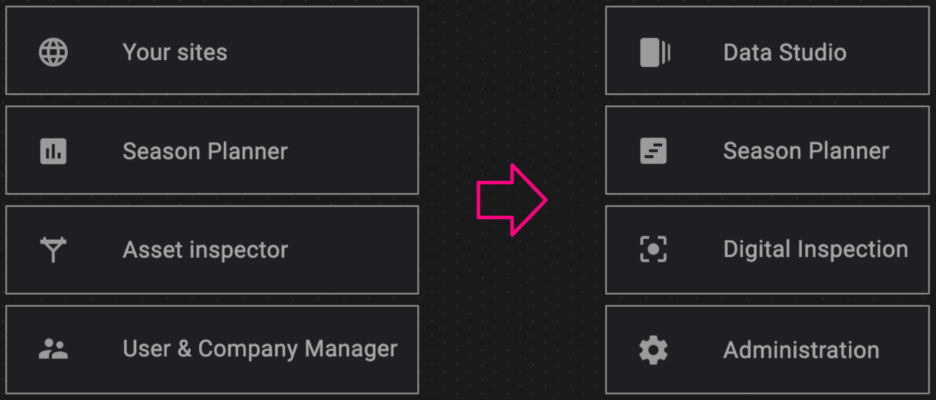
2. Aether Modules Rewording
| MODULE NAME | MODULE OLD NAME | DESCRIPTION |
| Data Studio | Your Sites | A workspace where you can visualize your data organized into projects, order analytics and use data computation and transformation tools on your raw data. |
| Data Acquisition | Data Capture | Manage and quality check your large scale or complex data acquisition to ensure timely capture. |
| Digital Inspection | Asset Inspector | Plan and perform all types of inspection by leveraging data acquisition and data processing workflows, and building automated reports for vision-based equipment inventory and diagnosis. |
| Insight | Asset Viewer | Visualize and aggregate data in 2D or 3D from the asset perspective, and explore and navigate your assets through interactive and contextual views. |
| Analysis | Analysis Management | Manage asset data analysis at scale. |
| Operations | Operations Management | Manage and monitor maintenance operations at asset level |
| Data Flow | Dataflow | Seamlessly import large batches of unstructured data from an external data lake |
| Season Planner | - | Automate your recurrent data collection and analysis operations |
| Administration | User & Company Manager | A workspace where you can visualize your data organized into projects, order analytics and use data computation and transformation tools on your raw data. |
3. Modules Icons Updates
4. Aether Analytic Catalog Updates
We have renamed and re-categorized our analytics catalog to make it consistent and allow easier tools access.
Our tools are now grouped into 4 categories:
- Computation Tools: Perform simple calculations on your dataset, such as calculating a volume, area, or point cloud difference, or generate advanced 2D maps and 3D models from your raw data.
- Feature Extraction: Extract business features such as assets, assets properties, or attributes from your raw data.
- Transformation Tools: Perform transformations on your data, such as converting, cropping, or aggregating data.
- Vegetation Assessment: Assess the condition or characteristics of vegetation, crops, or forests to understand its condition and how it changes over time.
| GROUP | TOOL NAME | DESCRIPTION | OLD GROUP | OLD NAME | OLD DESCRIPTION |
| COMPUTING TOOL | Advanced Cut and Fill | - | - | - | - |
| COMPUTING TOOL | Contour line | Creates contour lines from an elevation model | FREE ANALYTICS GENERAL PURPOSE |
Contour Lines | Generate contours connecting all points with same Height from an elevation model |
| COMPUTING TOOL | Custom composition map | Calculates custom composition map (RGB, CIR, …) from reflectance or hyperspectral map | AGRICULTURE - FIELD EXPERIMENT AGRICULTURE - PLANTATION & FORESTRY AGRICULTURE - PRODUCTION FIELD |
Composition Map - Custom | Calculate custom composition map |
| COMPUTING TOOL | Custom Contour Lines | Generate specific contours on the stock area | GENERAL PURPOSE | - | - |
| COMPUTING TOOL | Custom spectral index map | Computes spectral index map from custom formula and generates index map raster file | AGRICULTURE - FIELD EXPERIMENT AGRICULTURE - PLANTATION & FORESTRY AGRICULTURE - PRODUCTION FIELD |
Scouting Map - Custom | Calculate custom scouting map |
| COMPUTING TOOL | Digital terrain model | Creates an interpolated DTM to remove objects and vegetation above ground | FREE ANALYTICS | DTM | Create an interpolated DTM using polygons to remove small above ground objects such as vehicles |
| COMPUTING TOOL | Elevation change map | Generates an elevation change map and calculates cut and fill volumes between two surveys | FREE ANALYTICS | Change map | - |
| COMPUTING TOOL | Field digital terrain model | Creates an interpolated DTM of a field by removing above-ground vegetation | AGRICULTURE - FIELD EXPERIMENT AGRICULTURE - PLANTATION & FORESTRY AGRICULTURE - PRODUCTION FIELD |
Bare soil model estimation | Estimate terrain elevation |
| COMPUTING TOOL | Field Operation Report | - | - | - | - |
| COMPUTING TOOL | Ground coverage | Generates ground covered area from elevation model (DSM or DTM) in vector format | FREE ANALYTICS | - | Generate AOI in vector format from Elevation model (DSM or DTM) |
| COMPUTING TOOL | Photogrammetry | Generates 2D map and 3D model from a dataset of geotagged images | BASICS | - | Generate 2D and 3D models from your data |
| COMPUTING TOOL | Point cloud difference | Computes the difference (change) between two PCLs | FREE ANALYTICS | PCL Difference | - |
| COMPUTING TOOL | Powerline Modelization | Powerline Modelization in stereoscopy | POWER AND UTILITIES - BASICS | - | - |
| COMPUTING TOOL | Solar progress report | Qualifies the progress of a solar farm construction project | GENERAL PURPOSE | Solar construction monitoring | - |
| COMPUTING TOOL | Spectral index map | Computes generic spectral index map | AGRICULTURE - FIELD EXPERIMENT AGRICULTURE - PLANTATION & FORESTRY AGRICULTURE - PRODUCTION FIELD |
Scouting Maps - Generics | Calculate generic scouting maps |
| FEATURE EXTRACTION | Automated stockpile calculation | Detects and performs accurate volume calculation for stockpile inventory reporting | MINES AND AGGREGATES | Advanced Stockpiles | Detect, digitize and perform accurate volume calculations for stockpile inventory reporting |
| FEATURE EXTRACTION | Grid digitization | Generates grid from an area of interest with a custom grid size | AGRICULTURE - PLANTATION & FORESTRY | Grid designer | Generates grid from contour |
| FEATURE EXTRACTION | Haul road analysis | Detects, digitizes and extracts the geometry of haul roads (grades, widths, crossfalls) | MINES AND AGGREGATES | Haul Roads | Detect, digitize and extract the geometry of your haul roads (grades, widths, crossfalls) |
| FEATURE EXTRACTION | Image Inference for AEP | Detect anomalous component on images of powerlines | GENERAL PURPOSE | - | - |
| FEATURE EXTRACTION | Microplot digitization | Digitizes microplot boundaries | AGRICULTURE - FIELD EXPERIMENT | Microplot designer | Delineate the boundaries of microplots |
| FEATURE EXTRACTION | Mine safety analysis | Detects digitizes and measures the height of highwalls and safety berms | MINES AND AGGREGATES | Safety | Detect, digitize and measure the heights of your highwalls and berms |
| FEATURE EXTRACTION | Object Detection | Detects objects in orthomosaic images | GENERAL PURPOSE | - | - |
| FEATURE EXTRACTION | P&U Defect Detection | P&U Defect Detection | GENERAL PURPOSE | - | - |
| FEATURE EXTRACTION | Powerline Components and Defects Detection | This AI based algorithm detects powerline components and defects. | GENERAL PURPOSE | - | - |
| FEATURE EXTRACTION | Vehicle Detection | Detect vehicles in orthomosaic images | GENERAL PURPOSE | - | - |
| TRANSFORMATION TOOL | 3D vector data to elevation grid | Generates a digital terrain model from vector file | FREE ANALYTICS | - | Generates a digital terrain model from vector layer |
| TRANSFORMATION TOOL | Automatic point cloud classification | Semantically segments (classifies) a point cloud | POWER AND UTILITIES - BASICS | - | This task semantically segments (classifies) the point cloud. |
| TRANSFORMATION TOOL | Crop raster from microplots | - | AGRICULTURE | - | - |
| TRANSFORMATION TOOL | Duplicate Vector Layer | Duplicate a vector layer in the current project and survey | GENERAL PURPOSE | - | - |
| TRANSFORMATION TOOL | Elevation model to point vector | Allows the conversion of an elevation model into a point vector in .dxf format | FREE ANALYTICS | - | Analytic allowing the conversion of an elevation model into a point vector in dxf format |
| TRANSFORMATION TOOL | PCL to Mesh | Generate Mesh files from your point cloud | FREE ANALYTICS | - | - |
| TRANSFORMATION TOOL | Point cloud geographic conversion | Converts a point cloud in local coordinates | FREE ANALYTICS GENERAL PURPOSE |
Convert point cloud to local coordinates | Converts your point cloud in local coordinates |
| TRANSFORMATION TOOL | Point cloud simplification | Generates a less dense point cloud | FREE ANALYTICS | - | Generate a simplified point cloud (less dense) |
| TRANSFORMATION TOOL | Raster cropping | Crops a raster within an area of interest | FREE ANALYTICS | Raster crop | Crop your raster with an area of interest |
| TRANSFORMATION TOOL | Vector attribute addition | Add attributes to vector file from a .csv file | GENERAL PURPOSE | Join attributes | Join CSV attributes to vector file |
| VEGETATION ASSESSMENT | Emergence characterization for field | Estimates crop vigor at emergence | AGRICULTURE - PRODUCTION FIELD | Emergence Characterization | - |
| VEGETATION ASSESSMENT | Flowering characterization from orthomosaic | Estimates the percentage of flowering for canola or sunflower | AGRICULTURE - FIELD EXPERIMENT AGRICULTURE - PRODUCTION FIELD SEASON PLANNER |
Flowering Characterization | - |
| VEGETATION ASSESSMENT | Flowering characterization from reflectance | Estimates the percentage of flowering for canola or sunflower | SEASON PLANNER | - | - |
| VEGETATION ASSESSMENT | Fraction of vegetation cover from orthomosaic for microplot | Estimates the fraction of ground covered by green vegetation | SEASON PLANNER | Fraction of Vegetation Cover from RGBorthomosaic | Fraction of Vegetation Cover from RGBorthomosaic |
| VEGETATION ASSESSMENT | Fraction of vegetation cover from reflectance for microplot | Estimates the fraction of ground covered by green vegetation | SEASON PLANNER | Fraction of vegetation cover from reflectance | - |
| VEGETATION ASSESSMENT | Fraction of vegetation cover from spectral index | Estimates the fraction of ground covered by green vegetation | AGRICULTURE - FIELD EXPERIMENT AGRICULTURE - PLANTATION & FORESTRY AGRICULTURE - PRODUCTION FIELD |
Fraction of Vegetation Cover | - |
| VEGETATION ASSESSMENT | Plant count & emergence from orthomosaic for microplot | Estimates plant count and emergence for row crops | SEASON PLANNER | Plant count & emergence from orthomosaic | Detect missing plants and estimate plant (stand) count |
| VEGETATION ASSESSMENT | Plant count & emergence from reflectance for microplot | Estimates plant count and emergence for row crops | SEASON PLANNER | Plant count & emergence from multispectral | - |
| VEGETATION ASSESSMENT | Plant count & emergence from spectral index for microplot | Estimates plant count and emergence for row crops in microplots | AGRICULTURE - FIELD EXPERIMENT | Plant count and emergence | Estimate plant count and emergence for row crops |
| VEGETATION ASSESSMENT | Plant count for field | Estimates plant count in row crops | AGRICULTURE - PRODUCTION FIELD | Plant count | Detect missing plants and estimate plant (stand) count |
| VEGETATION ASSESSMENT | Plant height for field | Estimates plant or tree height for fields, forests or plantations | AGRICULTURE - PLANTATION & FORESTRY AGRICULTURE - PRODUCTION FIELD |
Plant height for production field | Estimate plant height |
| VEGETATION ASSESSMENT | Plant height for microplot | Estimates plant height in microplots | AGRICULTURE - FIELD EXPERIMENT SEASON PLANNER |
Plant height for trial field | Estimates plant height |
| VEGETATION ASSESSMENT | Plant height from LiDAR for microplot | Estimates plant height in microplots | AGRICULTURE - FIELD EXPERIMENT | Plant height from LiDAR | Generate plant height statistics from LiDAR file |
| VEGETATION ASSESSMENT | Raster statistics extraction for field | - | AGRICULTURE - FIELD EXPERIMENT AGRICULTURE - PRODUCTION FIELD SEASON PLANNER |
statistics for production field | Extract statistical metrics of raster map |
| VEGETATION ASSESSMENT | Raster statistics extraction for microplot | Extracts statistical metrics of raster file | AGRICULTURE - FIELD EXPERIMENT | Statistics for trial field | Extract statistical metrics of raster map |
| VEGETATION ASSESSMENT | Reflectance statistics extraction for microplot | Index Statistics from reflectance | SEASON PLANNER | Index statistics from reflectance | - |
| VEGETATION ASSESSMENT | Row vectorization for field | Detects, digitizes and measures rows within large field | AGRICULTURE - PRODUCTION FIELD | Row vectorization for production field | Detect, digitize and measure rows within fields |
| VEGETATION ASSESSMENT | Row vectorization for microplot | Detects, digitizes and measures rows within microplots | AGRICULTURE - FIELD EXPERIMENT | Row vectorization for trial field | Detect, digitize and measure rows within microplots |
| VEGETATION ASSESSMENT | Stay Green from orthomosaic | Measures crop ability to stay as a green growing plant in late-season plant | AGRICULTURE - FIELD EXPERIMENT AGRICULTURE - PRODUCTION FIELD SEASON PLANNER |
Stay Green | - |
| VEGETATION ASSESSMENT | Stay Green from reflectance | Measures crop ability to stay as a green growing plant in late-season plant | SEASON PLANNER | - | - |
| VEGETATION ASSESSMENT | Tree density indicator | Calculates tree density statistics | AGRICULTURE - PLANTATION & FORESTRY | - | - |
| VEGETATION ASSESSMENT | Tree detection | Detects trees in plantation or forest | AGRICULTURE - PLANTATION & FORESTRY | - | - |
| VEGETATION ASSESSMENT | Tree detection and analysis | Detects trees, measures tree height and provides advanced health and density indicators | AGRICULTURE - PLANTATION & FORESTRY | Advanced tree analysis | - |
| VEGETATION ASSESSMENT | Vegetation encroachment | Detects and inventories collisions between vegetation and powerline utilities | POWER AND UTILITIES - BASICS | - | - |
| VEGETATION ASSESSMENT | Vegetation encroachment advanced | - | - | - | - |
| VEGETATION ASSESSMENT | Weed detection for field | Detects weeds and generates a prescription map | AGRICULTURE - PRODUCTION FIELD | Weed Management | Detects weeds on bare soil or row crops and generates a prescription map. |
| SEASON PLANNER | Flowering characterization from orthomosaic | Estimates the percentage of flowering for canola or sunflower | AGRICULTURE - FIELD EXPERIMENT AGRICULTURE - PRODUCTION FIELD SEASON PLANNER |
Flowering Characterization | - |
| SEASON PLANNER | Flowering characterization from reflectance | Estimates the percentage of flowering for canola or sunflower | - | - | - |
| SEASON PLANNER | Fraction of vegetation cover from orthomosaic for microplot | Estimates the fraction of ground covered by green vegetation | - | Fraction of Vegetation Cover from RGBorthomosaic | Fraction of Vegetation Cover from RGBorthomosaic |
| SEASON PLANNER | Fraction of vegetation cover from reflectance for microplot | Estimates the fraction of ground covered by green vegetation | - | Fraction of vegetation cover from reflectance | - |
| SEASON PLANNER | Plant height for microplot | Estimates plant height in microplots | AGRICULTURE - FIELD EXPERIMENT SEASON PLANNER |
Plant height for trial field | Estimates plant height |
| SEASON PLANNER | Stay Green from orthomosaic | Measures crop ability to stay as a green growing plant in late-season plant | AGRICULTURE - FIELD EXPERIMENT AGRICULTURE - PRODUCTION FIELD SEASON PLANNER |
Stay Green | - |
| SEASON PLANNER | Stay Green from reflectance | Measures crop ability to stay as a green growing plant in late-season plant | - | - | - |
| SEASON PLANNER | Plant count & emergence from reflectance for microplot | Estimates plant count and emergence for row crops | - | Plant count & emergence from multispectral | - |
| SEASON PLANNER | Plant count & emergence from orthomosaic for microplot | Estimates plant count and emergence for row crops | - | Plant count & emergence from orthomosaic | Detect missing plants and estimate plant (stand) count |
| SEASON PLANNER | Reflectance statistics extraction for microplot | Index Statistics from reflectance | - | Index statistics from reflectance | - |
