Tree Detection and Analysis
Ce flux de travail tout-en-un vous permettra de détecter les arbres, de mesurer la hauteur des arbres et de fournir des indicateurs avancés de santé et de densité.
1. Entrées et paramètres
- Un MNS extrait du procédé de photogrammétrie
- Carte de réflectance (R, G, B, RE, NIR requis) extraite du processus de photogrammétrie
- Limites de champ définissant la zone d'intérêt ( Comment créer des limites de champ )
- Hauteur minimale de l'arbre : hauteur minimale acceptée de la plante
- Rayon minimal de la canopée : rayon minimal accepté de la canopée
- Maximum Canopy Radius : rayon maximal de canopée accepté
- Taille des tuiles de la grille
- Densité optimale des arbres : Nombre idéal d'arbres par hectare (utilisé pour les indicateurs de densité)
2. Livrables
- Vecteur de couronnes d'arbres
- Vecteur de densité des cimes des arbres
- Vecteur de densité AOI
- Vecteur de densité de grille AOI
Statistiques de l'indice de végétation des couronnes d'arbres :
- Statistiques des cimes des arbres NDVI
- Statistiques des cimes des arbres NDRE
- Statistiques sur les cimes des arbres CCCI
- Statistiques des cimes des arbres MSAVI2
3. Attributs
Ce sont les attributs des livrables csv et geojson.
Cime d'arbre :
- tree_id : identifiant unique de l'arbre
- treetop_height : Hauteur de l'arbre en m
- tree_area : surface de cime en m2
Densité des cimes des arbres :
- tree_id : identifiant unique de l'arbre
- min_tree_top_distance : distance de l'arbre le plus proche (cime d'arbre à cime d'arbre)
- min_tree_top_distance_unit : unité
- mean_tree_top_distance : distance moyenne des arbres les plus proches (arbre à arbre)
- mean_tree_top_distance_unit : unité
- min_tree_crown_distance : distance de la couronne la plus proche (couronne à couronne)
- min_tree_crown_distance_unit : unité
- mean_tree_crown_distance : distance moyenne des couronnes les plus proches
- mean_tree_crown_distance_unit : unité
- nb_touching_crowns : nombre de couronnes qui touchent l'arbre (ne peut être supérieur à 5)
Densité AOI et densité de grille :
- number_of_trees : nombre d'arbres dans la zone d'intérêt (AOI)
- tree_density : nombre d'arbres par ha dans la zone d'intérêt
- tree_density_unit : unité
- tree_density_deviation : 100*(tree_density - ideal_tree_density)/ideal_tree_density.
- tree_density_deviation_unit : unité
- tree_area : surface couverte par les cimes dans l'AOI
- tree_area_unit : unité
- mean_tree_top_distance : distance moyenne entre les arbres dans la zone d'intérêt (distance moyenne des cinq arbres les plus proches pour chaque arbre)
- mean_tree_top_distance_unit : unité
- mean_min_tree_top_distance : distance moyenne la plus faible entre les arbres dans la zone d'intérêt (c'est-à-dire la distance moyenne entre l'arbre le plus proche pour chaque arbre)
- mean_min_tree_top_distance_unit : unité
- mean_tree_crown_distance : distance moyenne entre les cimes dans la zone d'intérêt (c'est-à-dire la distance moyenne des cinq cimes les plus proches pour chaque arbre)
- mean_tree_crown_distance_unit : unité
- mean_min_tree_crown_distance : distance moyenne la plus faible entre chaque cime dans la zone d'intérêt (c'est-à-dire la distance moyenne de la cime la plus proche pour chaque arbre)
- mean_min_tree_crown_distance_unit : unité
- mean_nb_touching_crowns : nombre moyen de couronnes qui touchent une couronne dans l'AOI
4. Flux de travail
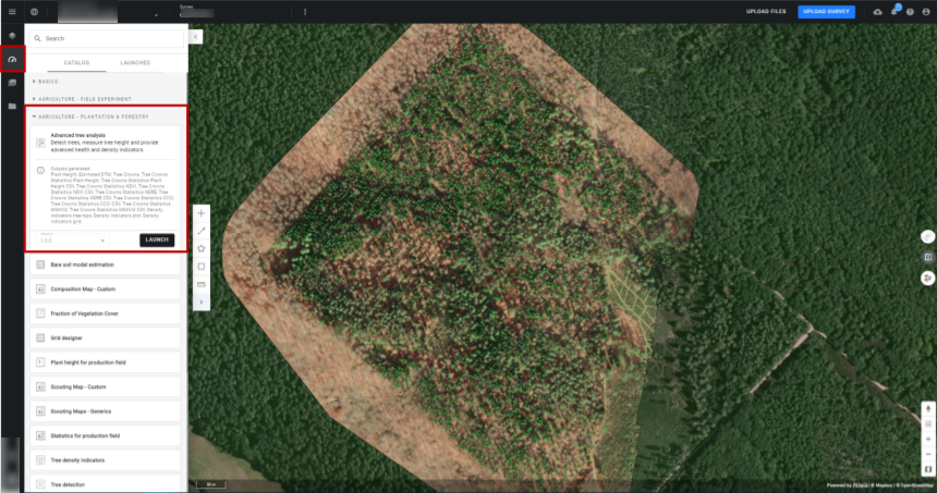
Étape 1 : Une fois dans votre projet, vous devez lancer l'analytique « Analyse avancée de l'arbre » à partir du catalogue analytique.
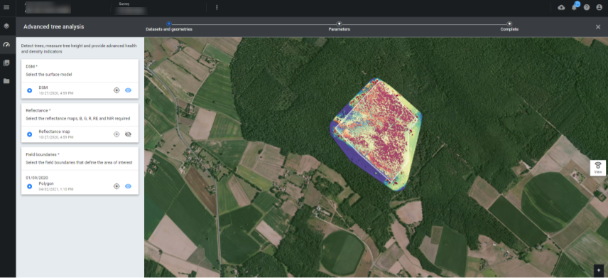
 Étape 2 : Sélectionnez vos entrées de fichier, DSM, carte de réflectance et limites de champ. Vous pouvez cliquer sur la petite icône en forme d'œil pour visualiser les calques.
 Étape 3 : Définissez vos paramètres et cliquez sur le bouton « Lancer l'analyse arborescente avancée ».
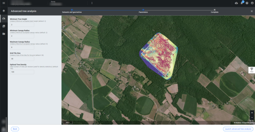
- Hauteur minimale de l'arbre : 2 mètres par défaut
- Rayon minimum de la canopée : 2 mètres par défaut
- Rayon maximal de la canopée : 8 mètres par défaut
- Taille des carreaux de la grille : 30 mètres par défaut
- Densité optimale des arbres : 100 arbres par hectare par défaut
5. Les résultats
Vous pouvez visualiser les résultats en sélectionnant la couche "Inventaire" dans la section DONNÉES D'ENQUÊTE dans le menu de gauche.
- Lors de l'affichage des couronnes d'arbres, vous pouvez choisir d'afficher les résultats en fonction d'attributs spécifiques, en ouvrant le panneau d'informations.
- Vous pouvez choisir entre :
- Neutre
- Surface de la cime des arbres
- Hauteur de l'arbre
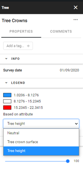
La carte affichera une classification basée sur la couleur et la légende sera visible sur le panneau d'information.
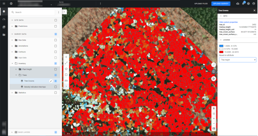 En cliquant sur un arbre détecté, les attributs de cet arbre apparaîtront également dans le panneau d'information.
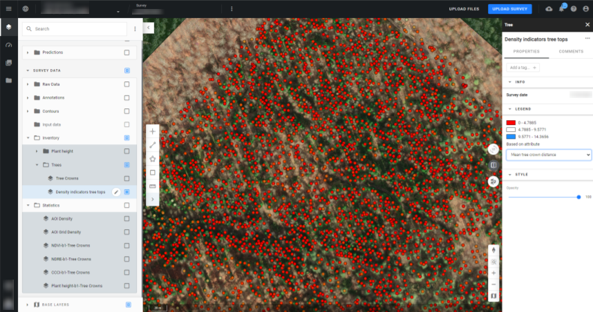
- Lors de l'affichage de la densité des cimes des arbres, vous pouvez choisir d'afficher les résultats en fonction d'attributs spécifiques, en ouvrant le panneau d'informations.
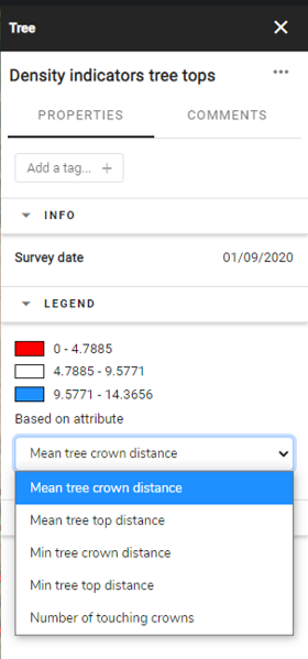
Vous pouvez voir la densité au niveau de l'arbre :
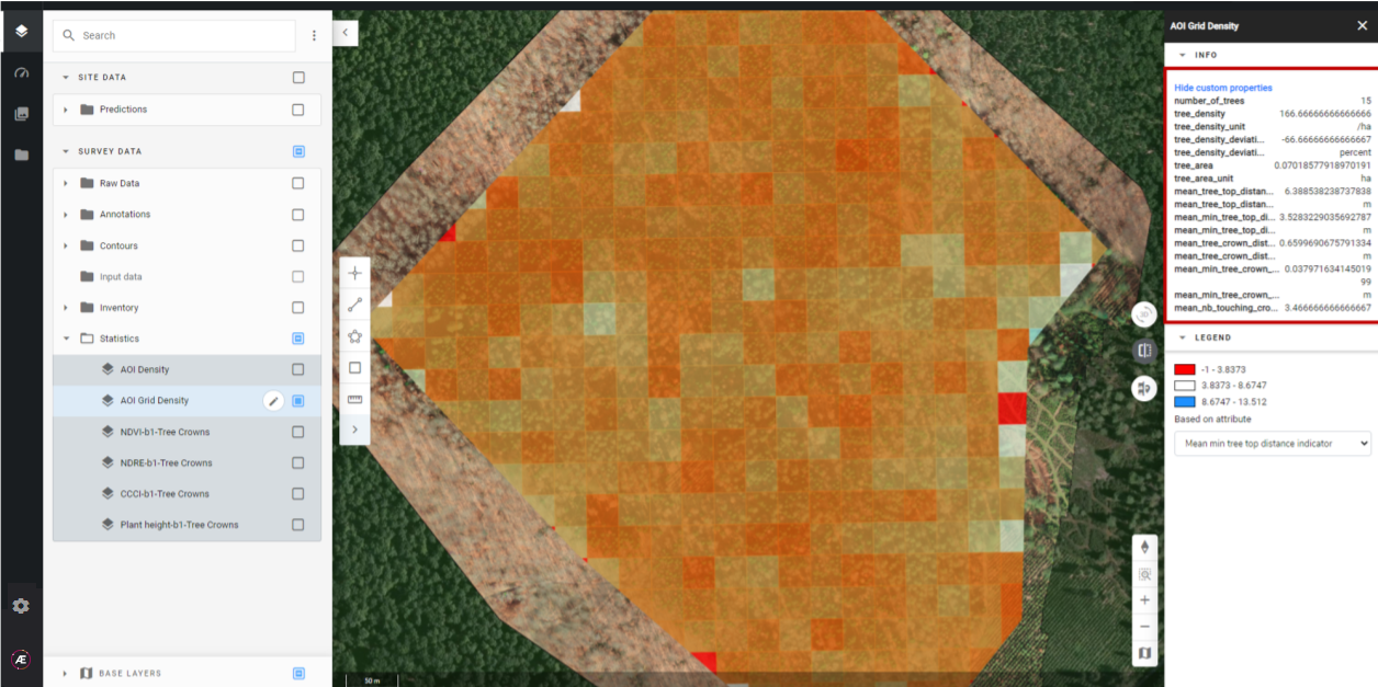
- Lors de la visualisation de la densité de la grille AOI, vous pourrez visualiser la densité des arbres par zones. Vous pouvez également choisir l'attribut que vous souhaitez prendre en compte pour la visualisation de la grille.
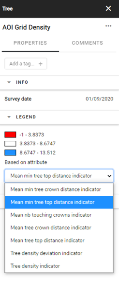
Dans ce cas, la grille affiche les résultats en fonction de l'attribut « Mean min tree top distance indicator » :
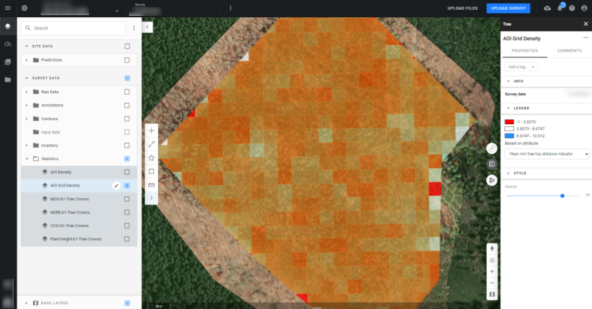
En cliquant sur une zone déterminée de la grille, vous pourrez voir les attributs de la zone sur le panneau d'informations :